| Identifikation | |
| Signatur | GFD 2/1 |
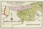
| Titel | Jönköping (Karte von Fredrik Adolf Wiblingen, um 1790–1805) |
| Laufzeit | ca. 1790 – ca. 1805 |
| Verzeichnungsstufe | Einzelstück |
| Umfang (Stückzahl) | 1 |
| Objekttyp | Digitales Foto |
| Bilder |
|
| Inhalt und innere Ordnung | |
| Form und Inhalt | Karte von Jönköping, ca. 1790-1805 // Autor: Fredrik Adolf Wiblingen // Standort: The Swedish National Land Survey’s database |
| Orte | Jönköping |
| Zugangs- und Benutzungsbestimmungen | |
| Zugangsbestimmungen / Sperrfrist | öffentlich |
| Kopien/Reproduktionen | Digitalisat: Urheber unbekannt // Quelle: Wikimedia Commons // Lizenz: Public Domain |
| Verzeichnungskontrolle | |
| Erstellt | 2022-05-03 09:11:32 / vrukavina |
| Aktualisiert | 2023-10-15 21:44:30 / feggimann |
| Permalink | https://archives.georgfischer.com/objects/124088 |
| Thumb | Metadaten | Download | Löschen |
|---|---|---|---|
|
ID: 83824 Filename: gfd_2_1-0001.png Original Name: wiblingen-jonkoping.png Size: 5.47 MB Md5: 149b15f6a0414e8c9f1a4f0c72091388 |
Download Master Web Version (0.17 MB) |