| Identifikation | |
| Signatur | GFD 2/130 |
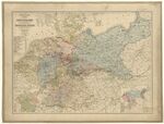
| Titel | Deutschland (Karte, 1850) |
| Laufzeit | 1850 |
| Verzeichnungsstufe | Einzelstück |
| Umfang (Stückzahl) | 1 |
| Objekttyp | Digitales Foto |
| Bilder |
|
| Inhalt und innere Ordnung | |
| Form und Inhalt | Karte von Deutschland, 1850 // Zeichner: unbekannt // Standort: Bibliothèque nationale de France, département Cartes et plans, GE C-7508 |
| Orte | Deutschland |
| Zugangs- und Benutzungsbestimmungen | |
| Zugangsbestimmungen / Sperrfrist | öffentlich |
| Kopien/Reproduktionen | Digitalisat: Bibliothèque nationale de France // Quelle: Wikimedia Commons // Lizenz: Public Domain |
| Verzeichnungskontrolle | |
| Erstellt | 2022-09-27 08:33:16 / vrukavina |
| Aktualisiert | 2023-05-10 11:22:39 / lpersi |
| Permalink | https://archives.georgfischer.com/objects/129900 |
| Thumb | Metadaten | Download | Löschen |
|---|---|---|---|
|
ID: 84189 Filename: gfd_2_130-0001.jpg Original Name: politisch-statistische-karte-von-deutschland-und-den-konigreichen-der-niederlande-und-belgien-von-h-mahlmann-btv1b53085922j.jpg Size: 11.56 MB Md5: 03ee62a1dc69b6a9836e1dd6ef47a877 |
Download Master Web Version (0.25 MB) |