| Identifikation | |
| Signatur | GFD 2/174 |
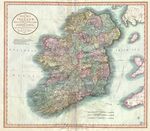
| Titel | Irland (Karte von John Cary, 1799) |
| Laufzeit | 1799 |
| Verzeichnungsstufe | Einzelstück |
| Umfang (Stückzahl) | 1 |
| Objekttyp | Digitales Foto |
| Bilder |
|
| Inhalt und innere Ordnung | |
| Form und Inhalt | Karte von Irland, 1799 // Kartograf: John Cary // Medium: Cary, John: Cary’s New Universal Atlas, containing distinct maps of all the principal states and kingdoms throughout the World. From the latest and best authorities extant. London: Printed for J. Cary, Engraver and Map-seller, No. 181, near Norfolk Street, Strand, 1808. // Standort: unbekannt |
| Orte | Irland |
| Zugangs- und Benutzungsbestimmungen | |
| Zugangsbestimmungen / Sperrfrist | öffentlich |
| Kopien/Reproduktionen | Digitalisat: Geographicus Rare Antique Maps // Quelle: Wikimedia Commons // Lizenz: Public Domain |
| Verzeichnungskontrolle | |
| Erstellt | 2023-02-14 16:33:17 / vrukavina |
| Aktualisiert | 2023-10-15 21:51:24 / feggimann |
| Permalink | https://archives.georgfischer.com/objects/132469 |
| Thumb | Metadaten | Download | Löschen |
|---|---|---|---|
|
ID: 85714 Filename: gfd_2_174-0001.jpg Original Name: 1799-cary-map-of-ireland-geographicus-ireland-cary-1799.jpg Size: 6.57 MB Md5: 06038d73b270d7bb94961bee3bea8c24 |
Download Master Web Version (0.31 MB) |