| Identifikation | |
| Signatur | GFD 2/2 |
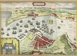
| Titel | Helsingør (Karte von Georg Braun und Frans Hogenberg, 1588) |
| Laufzeit | 1588 |
| Verzeichnungsstufe | Einzelstück |
| Umfang (Stückzahl) | 1 |
| Objekttyp | Digitales Foto |
| Bilder |
|
| Inhalt und innere Ordnung | |
| Form und Inhalt | Karte von Helsingør, 1588 // Autoren: Georg Braun, Frans Hogenberg // Medium: John Danstrup: Danmarks historia. Från äldsta tid till våra dagar. Första bandet. Malmö: Allhems förlag, 1946 // Standort: unbekannt |
| Orte | Helsingör |
| Zugangs- und Benutzungsbestimmungen | |
| Zugangsbestimmungen / Sperrfrist | öffentlich |
| Kopien/Reproduktionen | Digitalisat: Wikimedia user Thuresson 2007 // Quelle: Wikimedia Commons // Lizenz: Public Domain |
| Verzeichnungskontrolle | |
| Erstellt | 2022-05-03 09:28:08 / vrukavina |
| Aktualisiert | 2023-05-10 10:32:31 / lpersi |
| Permalink | https://archives.georgfischer.com/objects/124089 |
| Thumb | Metadaten | Download | Löschen |
|---|---|---|---|
|
ID: 85831 Filename: gfd_2_2-0001.jpg Original Name: kronborg-braun-hogenberg.jpg Size: 0.55 MB Md5: d6bd71db3cc28a873158e93c67cd8ac1 |
Download Master Web Version (0.22 MB) |
