| Identifikation | |
| Signatur | GFKS 2/881 |
| Altsignatur | Rohr 881 |
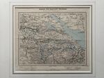
| Titel | Karte Kanton Thurgau. Massstab 1:250'000 |
| Laufzeit | 1870 |
| Urheber:in | ca. 1870 / Wettstein, Heinrich |
| Verzeichnungsstufe | Einzelstück |
| Umfang (Stückzahl) | 1 |
| Objekttyp | Plan |
| Bilder |
|
| Inhalt und innere Ordnung | |
| Form und Inhalt | Wettstein, Heinrich (1831-1895) [Naturforscher]; Topgraphiesche Anstalt von Wurster, Randegger & Co. [Verleger]: Karte Kanton Thurgau. Massstab 1:250'000; Herkunft: Schulkarte bzw. Schulatlas; Winterthur. Lithographie; 21 x 27 cm, gerahmt, koloriert. |
| Schlagwörter | Landkarte :: Werkstatt |
| Zugangs- und Benutzungsbestimmungen | |
| Zugangsbestimmungen / Sperrfrist | öffentlich |
| Physische Beschaffenheit und technische Anforderungen | Lithographie; 21 x 27 cm, gerahmt, koloriert |
| Digitalisiert | 2023 / GF Konzernarchiv |
| Verzeichnungskontrolle | |
| Erstellt | 2018-05-10 22:57:45 / feggimann |
| Aktualisiert | 2023-02-21 11:54:29 / hbarteld |
| Permalink | https://archives.georgfischer.com/objects/49456 |
| Thumb | Metadaten | Download | Löschen |
|---|---|---|---|
|
ID: 85855 Filename: gfks_2_881-0001.jpg Original Name: gfks-2-881.jpg Size: 1.06 MB Md5: 0cf6168a3e88b7af35e79200a803daf1 |
Download Master Web Version (0.24 MB) |