| Identifikation | |
| Signatur | EBA 1/110 |
| Altsignatur | Karten 507 |
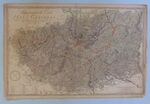
| Titel | Topographische Carte des Harzgebirges |
| Laufzeit | 1789 / unbekannt |
| Verzeichnungsstufe | Einzelstück |
| Umfang (Stückzahl) | 1 |
| Objekttyp | Plan |
| Bilder |
|
| Inhalt und innere Ordnung | |
| Form und Inhalt | Topographische Carte des Harzgebirges |
| Orte | Harz |
| Zugangs- und Benutzungsbestimmungen | |
| Zugangsbestimmungen / Sperrfrist | öffentlich |
| Sprachen | Deutsch |
| Physische Beschaffenheit und technische Anforderungen | Karte, Masse (HxB): 56 x 84 cm |
| Digitalisiert | 2021 / Eisenbibliothek |
| Verzeichnungskontrolle | |
| Erstellt | 2015-03-06 16:07:03 / akraenzle |
| Aktualisiert | 2024-02-26 17:00:30 / feggimann 2022-02-18 17:32:40 / feggimann 2021-06-22 16:34:48 / lgerber 2021-06-22 16:28:41 / lgerber 2021-06-14 15:12:30 / lgerber 2020-03-09 09:54:56 / anton 2019-07-02 10:53:22 / feggimann 2016-02-07 23:59:24 / feggimann 2015-03-24 12:38:45 / gritter 2015-03-22 22:28:09 / feggimann 2015-03-22 22:27:43 / gritter |
| Permalink | https://archives.georgfischer.com/objects/3080 |
| Thumb | Metadaten | Download | Löschen |
|---|---|---|---|
|
ID: 83329 Filename: eba_1_110-0001.jpg Original Name: p1080616-1.jpg Size: 2.02 MB Md5: 51eb47bc0906cab67ef470ad632d4e5a |
Download Master Web Version (0.18 MB) |